What would Milwaukee County look like today if certain development projects had been completed according to initial plans? In a new series entitled “RetroFuture,” we at MKE Memoirs attempt to answer this question. Join us as we take a closer look at development plans that, for better or worse, never came to fruition.
Monumental changes are coming to Milwaukee’s lakefront. In the not so distant past, Mayor Tom Barrett, County Executive Chris Abele and Governor Scott Walker unveiled their vision for the gateway to the city. The plan calls for the relocation of two Interstate 794 ramps, the conversion of a portion of East Clybourn Street into a boulevard, the extension of Lincoln Memorial Drive to the Historic Third Ward, and the addition of a pedestrian bridge. The plan makes great strides to open up the perceived disconnect between downtown and Lake Michigan, often regarded as the city’s most valuable developmental resource.


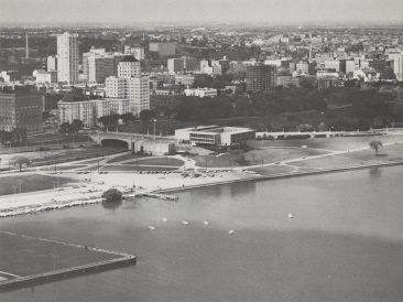
Ways of enhancing Milwaukee’s shoreline have long been on developers’ minds. The Lakefront Development Plan at the Milwaukee County War Memorial Center of 1968 stands out in particular. But before we dive into the specifics, let’s take a brief moment to review the history of the lot.
 Disigned by Eero Saarinen and constructed in 1957, the War Memorial building was built in response to the need of a city-wide cultural center and served three different functions. The open air Memorial Court was and remains the focal point of the center’s veterans-related functions. Two upper level floors provide space for offices and meeting rooms, while the lower levels housed the permanent collection of the Milwaukee Art Center.
The angular aesthetic of the building itself was purposeful. According to the County:
[The War Memorial] occupies a prominent position along the relatively open lake shore, its strongly sculptural character accented by its projection from the Juneau Park bluffs and its positions upon a sharply rising knoll of land fill. The War Memorial is thus prominently situated at perhaps the most critical point in all of Milwaukee, the point where the intensely developed core of the city meets the openness of Lake Michigan.
The original plan for the Center had called for additional landfill into the Lake to provide a proper platform and park setting for the building complex. This plan was abandoned and, as a result, the shoreline begins abruptly at the War Memorial’s feet, not allowing an adequate transition from building activities to the desirable park characteristics along the Lake.
Not long before the Lakefront Development Plan as proposed in 1968, a portion of the Chicago and Northwestern Railway ran between the War Memorial Center and downtown. But the County had purchased the land in 1946 for $7 million and tore out the remaining tracks.
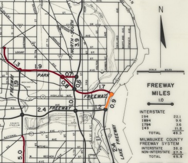 The impetus for the Lakefront Development Plan was the still infant freeway system, sweeping across the country. The City had decided to enclose downtown Milwaukee in an expressway loop, with multiple lanes of high-speed traffic on all sides. The infamous Park East Expressway was an integral part of this proposed project. In many ways, the City can still feel the stinging effects of these poorly thought-out freeway plans.
That plan included a one-mile stretch of freeway right along the old Chicago and Northwestern line. Apparently, the county had not learned its lesson about wasting valuable land resources.
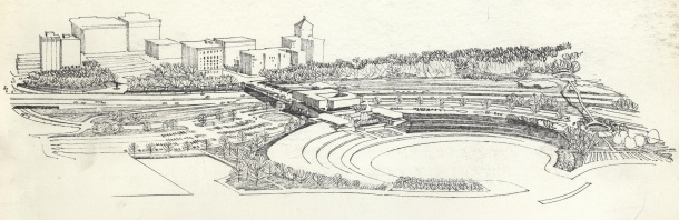
However, while the Lakefront Development Plan was disappointing West of the War Memorial, it more than made up for the proposed dull slaps of concrete to the East of the complex. The plan called for a shoreline fitting of the War Memorial.
To meet the demands of crowds ranging from a few hundred, to many thousands, the County would begin infilling a large swath of lake-bed to make room for a water exhibition lagoon, surrounded by a large, out door arena. The arena would be multipurpose and scalable, designed to have smaller, more intimate spectacles and large, public exhibitions all in one convenient location. Between the War Memorial and the proposed arena, art lovers could find a cozy plaza reserved for intimate public art exhibits and a statue garden. To the north of the man-made lagoon, near today’s Veterans Memorial, a small bay would be carved out to make room for special exhibitions.
To accommodate these profound changes to the lakefront, in addition to the never-to-be Lake Freeway, massive alterations to both pedestrian and automobile access were in order. The War Memorial bridge would be cut off to all traffic, instead offering a pleasant pedestrian deck with accommodations for special planting and an additional sculpture exhibition. The bridge would lead west, connecting to a promenade along the lake freeway and on to Wisconsin Avenue, bringing together the lakefront and the city center. An additional two pedestrian bridges were to be build, extending from Juneau Park, over the freeway, and down into McKinley Marina Park. Michigan Avenue would extend straight on to Lincoln Memorial Drive, which would have to shift eastward and cut through the park and around the lagoon to accommodate the freeway. Large swaths of park land would be cemented over, creating enough parking for nearly 1,000 cars.
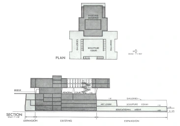
War Memorial Expansion
The War Memorial itself would see some modification and improvement. Expansions would be added both east and west of the existing complex, with the west serving as storage space for mechanical equipment and additional offices, and the east serving as an art lobby and educational areas.
Without hindsight, it’s hard to say how this development plan would have affected Milwaukee’s coast. The most glaringly obvious potential issue would be what to do with the future Quadracci Pavilion, designed by world-renowned architect Santiago Calatrava. It’s impossible to imagine Milwaukee’s most recognizable building sitting next to an immense water arena (It’s doubtful there would be enough room for the project in the first place). One also has to wonder how often this proposed development would have been used. The popularity of water and air exhibition shows has certainly ebbed since the plan was drafted. Would there be a high demand for a large arena on the lake today?
But credit where credit is due. This plan provides the War Memorial with the lakefront it deserves. Gradual, sloping steps down to the shoreline would be much more aesthetically pleasing than the cement brink and awkward, sharp drop-off that graces our coast today.
Overall, aside from the eyesore and waste of valuable land that would be a Lake Freeway, this plan had a lot of potential to it. It would be interesting to see how its completion would have altered the feel of the lakefront. And, as long as it wouldn’t interfere with the beloved Milwaukee Art Museum, this innovative development plan would be a welcome addition to the City of Milwaukee today!

